

NZ’s sodden January explained: what’s driven this month’s big wet?
- Written by The Conversation
It has been a month of umbrellas rather than sunscreen across much of New Zealand, with persistent rain, low sunshine and deadly storms dominating headlines and daily life.
For many people, it has felt like midsummer never really arrived. Is it simply bad luck, or is there something more going on?
As with most aspects of our climate and weather, the answer isn’t straightforward. It reflects the interplay between New Zealand’s geography, warmer-than-average ocean temperatures, large-scale regional climate patterns and long-term global warming.
What the data shows – and why it’s been so wet
Climate observations back up what many New Zealanders have been feeling this month. Across northern regions in particular, sunshine hours have been well below average, while rainfall totals have been far above normal.
In central Auckland, a weather station in Albert Park had recorded around 244mm by January 27 – nearly three times the (1981–2010) average for the month. At Mount Maunganui, the month-to-date total had climbed to roughly 385mm, more than four times the norm.
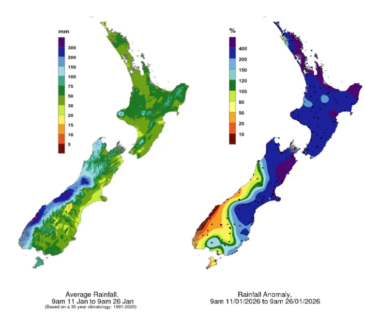
Similar patterns have been seen in many parts of the upper North Island, with repeated heavy rain events, high humidity and prolonged cloudy spells. The result has often been soggy soils, swollen rivers and increased risks of flooding and landslides.
While each storm that affects New Zealand is different, many of the systems visiting the country this summer share some common features. Several have originated in the tropics, subtropics or the north Tasman Sea before drifting south toward New Zealand. These systems typically carry warm, moisture-laden air – and the potential for intense rainfall.
When these moist air masses interact with cooler air from the south, or encounter New Zealand’s rugged topography, conditions become ripe for heavy rain.
As air is forced upwards over hills and mountain ranges – particularly along the Coromandel Peninsula, Bay of Plenty, East Cape and Gisborne regions – moisture condenses rapidly, producing very high rainfall totals. This is why northern and eastern parts of the country so often bear the brunt of these subtropical events.
The regional patterns loading the dice
One background factor this summer has been the lingering influence of La Niña, part of the El Niño–Southern Oscillation (ENSO) system that dominates climate variability across the Pacific.
During La Niña, atmospheric pressure tends to be lower than normal over Australia and the north Tasman Sea, and higher than normal to the south and east of New Zealand. This effectively flips our usual weather pattern on its head, reducing westerly winds and increasing the frequency of easterly and northeasterly flows.
Those northeasterly winds draw warm, humid air from the subtropics toward New Zealand. Because our temperatures are highly sensitive to wind direction, even small shifts can have large effects.
La Niña also tends to be associated with warmer-than-average sea surface temperatures, which have again been observed around New Zealand. So, when northeasterly winds blow across these warmer waters, they pick up additional heat and moisture, further fuelling heavy rainfall potential.
Another background driver that constantly shapes New Zealand’s weather and climate is the Southern Annular Mode (SAM), which describes the north–south movement of the westerly wind belt that circles Antarctica.
A positive SAM phase, which has dominated much of this summer, tends to bring higher pressures over the South Island and southern New Zealand. This allows storms from the subtropics more room to drift south and linger near the North Island.
Climate change as an intensifier
Overlaying these regional drivers is the broader influence of climate change, which is steadily warming both the atmosphere and the oceans surrounding New Zealand.
As the planet heats, the atmosphere can hold more moisture – about 7% more water vapour for every 1°C of warming. This means that when storms do develop, they have more fuel available, increasing the potential for heavier rainfall and stronger winds.
Climate change does not cause individual weather systems, nor does it directly control large-scale climate patterns like ENSO or the SAM. But it acts as a powerful intensifier.
Event-attribution studies in New Zealand to date have shown climate change can increase the total rainfall from intense storms by around 10–20%.
But for the most intense downpours – when the atmospheric “sponge” is wrung out most vigorously – rainfall intensities can increase by as much as 30%, depending on the frame of time being looked at. These short, extreme bursts of rain are often what cause the greatest damage.
There are still important uncertainties. Scientists are actively researching whether climate change will alter the frequency or strength of La Niña and El Niño events, but so far there is no clear answer. The same is true for long-term trends in the Southern Annular Mode.
What we can say with confidence is that background warming is shifting the risk profile.
As global temperatures continue to rise, the kinds of extremes we’ve experienced this season are likely to become more common. The biggest unanswered question is how quickly we can reduce greenhouse gas emissions to limit how severe these impacts ultimately become.
Read more https://theconversation.com/nzs-sodden-january-explained-whats-driven-this-months-big-wet-274416


